Water is one of our planet's most powerful forces, capable of both nurturing life and causing devastation. For centuries, humanity has sought to control this immense power through dam construction — and the results have been nothing short of monumental! 🌊
From the towering concrete arches of Hoover Dam to the sprawling reservoir created by Three Gorges Dam, each of these structures tells a story of human ingenuity, perseverance, and sometimes, cautionary lessons. For engineers, understanding the design principles, challenges, and impacts of these iconic dams is essential. Not only do these feats of engineering provide water storage, flood control, and hydropower, but they also embody some of the most innovative civil engineering concepts ever developed.
In this article, we take a deep dive into 10 iconic dams that every engineer should know. We’ll explore their technical designs, the engineering challenges they overcame, and why they hold a special place in the annals of engineering history. Whether you’re a civil engineer, a student, or simply curious about the marvels of infrastructure, this journey through the world's most famous dams will inspire and inform.
But first, what makes a dam truly iconic? Let’s break it down from an engineering point of view:
Understanding iconic dams provides insights into essential engineering concepts such as:
Each of the 10 dams we’ll explore in this article represents a crucial learning point in these areas. Let’s get started! 🚧
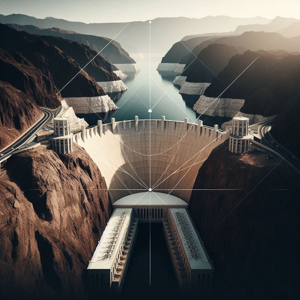
The Hoover Dam is one of the most iconic engineering marvels in the world — and for good reason. Completed in 1936 during the Great Depression, it stands as a testament to human resilience and ingenuity. The dam’s construction not only provided much-needed jobs during an economically challenging time but also transformed the southwestern United States by providing reliable water and power.
The Hoover Dam’s most notable feature is its gravity-arch design. This design is a perfect marriage of physics and materials science. The dam’s curved shape allows it to transfer the immense force of the Colorado River’s water into the canyon walls, effectively using the natural landscape to bolster its strength.
In a traditional gravity dam, the structure relies solely on its weight to resist the force of water. In contrast, a gravity-arch dam like Hoover Dam uses the arch effect to distribute the pressure outward. This innovative design allowed engineers to build a taller and thinner structure without compromising safety or stability.
The concrete used in the Hoover Dam is still curing today! Engineers estimated that it would take 125 years for all of the concrete to fully cure. This speaks to the massive scale of the project and the challenges posed by using such large quantities of material.
Hoover Dam teaches us several valuable lessons:
In conclusion, Hoover Dam stands as a symbol of what’s possible when human ingenuity meets necessity. It’s a reminder that engineering is not just about solving technical problems — it’s about shaping the world in ways that improve lives and inspire future generations.
When it comes to sheer size and impact, few structures in the world compare to the Three Gorges Dam. Located on the Yangtze River in China, it is the largest hydroelectric dam in the world in terms of installed capacity. Beyond its engineering feats, this dam has been a symbol of China’s rapid modernization, but it has also sparked significant environmental and social debates.
The Three Gorges Dam is a concrete gravity dam, meaning it relies on its sheer weight to hold back the immense force of the Yangtze River. What makes this dam unique is its unprecedented scale and the range of engineering challenges it had to overcome to make it a reality.
The dam’s hydropower station has 32 main turbines, along with two smaller generators, for a total installed capacity of 22,500 megawatts. This immense power output is enough to meet the electricity demands of millions of homes, making it a cornerstone of China’s energy strategy.
Despite its benefits, the Three Gorges Dam has not been without controversy. The project led to the displacement of over 1.3 million people and the submersion of thousands of cultural and archaeological sites. There are also ongoing concerns about the dam’s environmental impact, including changes to the river’s ecosystem and increased risk of landslides in the surrounding areas.
The immense weight of the water held back by the Three Gorges Dam’s reservoir is so significant that scientists believe it can slightly alter the Earth's rotation. According to NASA, the dam’s reservoir has shifted enough mass to lengthen the day by 0.06 microseconds!
The Three Gorges Dam offers a wealth of lessons for engineers:
In conclusion, the Three Gorges Dam stands as a symbol of human ambition and engineering prowess. It showcases the incredible potential of hydropower to meet energy demands, while also reminding us of the complexities and responsibilities that come with large-scale infrastructure projects. 🌟
Nestled on the border between Brazil and Paraguay, Itaipu Dam is one of the world's most remarkable engineering achievements. It held the title of the largest hydroelectric dam by energy production for decades until recently surpassed by China’s Three Gorges Dam. Still, Itaipu remains a critical symbol of bi-national cooperation, producing over 75% of Paraguay's electricity and supplying a significant portion of Brazil’s power needs.
What makes Itaipu truly iconic is its engineering complexity and power output. It represents a harmonious blend of civil, mechanical, and electrical engineering that showcases humanity’s ability to harness the raw power of nature for sustainable energy.
Itaipu Dam is a concrete gravity dam, but what sets it apart is its modular construction and massive spillway system. The dam has 20 generator units, each capable of producing 700 megawatts, for a total installed capacity of 14 gigawatts.
The dam’s design also features an innovative spillway system, capable of handling 62,200 cubic meters of water per second — equivalent to the combined flow of 40 Niagara Falls! This spillway system ensures that the dam can release excess water during heavy rainfall, preventing overflow and potential structural damage.
One key engineering feature of Itaipu is its modular approach, which allows individual generator units to be taken offline for maintenance without disrupting the overall power supply. This ensures continuous operation and reliability, making Itaipu one of the most efficient and well-maintained dams in the world.
Building a dam of this magnitude was no small feat. The Paraná River is one of the largest rivers in South America, with immense seasonal flows that posed significant challenges during construction. Engineers had to divert the river temporarily, constructing a massive earth-and-rock embankment to control the flow while the dam was built.
Additionally, Itaipu faced the challenge of balancing energy production with environmental conservation. Engineers and environmentalists worked together to reforest areas around the reservoir and protect local biodiversity.
In 2016, Itaipu set a world record for annual energy production, generating 103.1 terawatt-hours of electricity in a single year! This record remains one of the highest in hydropower history, emphasizing the dam’s efficiency and reliability.
Itaipu Dam offers several key takeaways for engineers:
In Conclusion… 🌱 Itaipu Dam is more than just a powerhouse — it’s a symbol of unity, innovation, and sustainability. Its construction required advanced engineering concepts, innovative solutions to complex problems, and a commitment to long-term environmental stewardship.
For engineers, Itaipu is a shining example of how large-scale hydropower projects can balance technical excellence, diplomatic cooperation, and environmental responsibility. It’s a reminder that engineering is not just about solving problems — it’s about building a better future. 🌟
The Aswan High Dam, situated across the Nile River in Egypt, is one of the most influential engineering projects of the 20th century. It revolutionized water management in the region by taming the world's longest river and providing Egypt with year-round water control, preventing devastating floods and enabling agricultural growth.
The dam's completion marked a major turning point in Egypt's development, symbolizing national independence and modernization. It also created Lake Nasser, one of the largest artificial reservoirs in the world, fundamentally transforming Egypt's water management and energy production.
The Aswan High Dam is an embankment dam with a core wall made of clay and rock-fill outer layers. This design provides strength and stability while minimizing construction costs.
The dam also incorporates large spillways to manage excess water and a hydropower station that generates 2.1 gigawatts of electricity, significantly contributing to Egypt’s energy supply. The electricity generated by the dam powers cities, industries, and farms across the country, making it a critical component of Egypt’s infrastructure.
While the Aswan High Dam brought many benefits, it has also faced significant criticism due to its environmental and cultural impacts. The creation of Lake Nasser submerged thousands of villages, historical sites, and fertile farmland, displacing over 100,000 people.
The dam also led to the disruption of natural sediment flow in the Nile River, which has reduced soil fertility downstream. This has forced farmers to rely on chemical fertilizers, which has raised concerns about long-term agricultural sustainability. Additionally, the dam’s presence has contributed to the spread of waterborne diseases, such as schistosomiasis, in the region.
One of the most remarkable feats of engineering associated with the Aswan High Dam was the relocation of Abu Simbel, a 3,000-year-old temple complex built by Pharaoh Ramses II. The temples were at risk of being submerged by Lake Nasser, so an international team of engineers and archaeologists worked together to move the temples piece by piece to higher ground.
This monumental rescue operation is considered one of the greatest archaeological engineering achievements in history.
The Aswan High Dam offers numerous lessons for engineers:
In Conclusion… 🌱 The Aswan High Dam stands as a symbol of progress and independence for Egypt. It demonstrates the power of engineering to reshape entire regions, bringing both great benefits and significant challenges.
For engineers, the dam serves as a reminder of the delicate balance between development and sustainability, and it offers valuable insights into water management, energy production, and the social impacts of large infrastructure projects.
It’s a powerful example of how engineering can change the course of history, shaping not only landscapes but also the lives of millions of people. 🌍
The Glen Canyon Dam is a critical piece of water infrastructure in the southwestern United States, creating Lake Powell, the second-largest man-made reservoir in the country. Built as part of the Colorado River Storage Project, the dam was designed to regulate water flow from the Colorado River, provide hydroelectric power, and ensure water security for the arid southwestern states.
While the dam has provided significant benefits in terms of water storage and energy generation, it has also been the subject of intense environmental controversy, with ongoing debates about the ecological impact of damming the Colorado River and the long-term sustainability of Lake Powell.
Like the Hoover Dam, Glen Canyon Dam is an arch-gravity dam, which uses both the arch’s curvature and gravity’s force to hold back the water. This design is ideal for narrow canyon locations, where the canyon walls provide structural support to counteract the immense pressure of the water.
The dam was built with 5 million cubic yards (3.8 million cubic meters) of concrete, making it one of the largest concrete structures in the United States. Its reservoir, Lake Powell, stretches 186 miles (299 km) upstream, with a shoreline longer than the U.S. Pacific Coast.
The Glen Canyon Dam serves several critical functions for the southwestern United States:
While Glen Canyon Dam has been a vital resource for water management in the southwest, it has also been highly controversial due to its impact on the environment and indigenous communities.
The construction of the Glen Canyon Dam posed significant engineering challenges, which required innovative solutions:
One of the biggest threats to Glen Canyon Dam is climate change. The southwestern United States is experiencing a prolonged megadrought, reducing the inflows into Lake Powell.
As water levels drop, the dam faces operational risks, including the potential for turbines to stop working if the water level falls below minimum power pool. This situation has led to discussions about the dam’s future, with some calling for a rethinking of water management strategies in the Colorado River Basin.
Glen Canyon Dam offers several important lessons for engineers:
In Conclusion… 🌍 The Glen Canyon Dam is both a technological triumph and a symbol of controversy. It has played a vital role in water and energy management for over half a century, but it also serves as a reminder of the environmental costs of dam construction.
As the Colorado River faces unprecedented drought conditions, the future of Lake Powell and the Glen Canyon Dam remains uncertain. For engineers, it presents a case study in balancing infrastructure development with sustainability and environmental stewardship.
The lessons learned from Glen Canyon Dam will continue to shape water resource management strategies as engineers tackle the complex challenges of the 21st century. 💡
The Oroville Dam, located on the Feather River in Northern California, is the tallest dam in the United States and a key component of the California State Water Project (SWP). This massive earthfill embankment dam is responsible for creating Lake Oroville, one of California’s largest reservoirs, which plays a critical role in providing water to millions of residents, generating hydroelectric power, and preventing flooding in the region.
Oroville Dam is not only a significant engineering achievement but also a lesson in resilience after a major spillway failure in 2017. This failure highlighted the importance of dam maintenance, emergency planning, and modernizing infrastructure to meet evolving environmental and safety challenges.
Unlike concrete dams such as the Hoover Dam or Glen Canyon Dam, the Oroville Dam is an earthfill embankment dam, meaning it is primarily made of compacted earth and rock materials.
This type of dam relies on gravity and the weight of the materials to resist the water pressure behind it. The core of the dam is made of impermeable clay, which prevents water seepage, while the outer layers consist of gravel, sand, and rock to provide stability.
The dam’s size and construction materials make it flexible and resilient, capable of withstanding seismic activity in an earthquake-prone region like California.
The Oroville Dam serves multiple purposes that are vital to California’s water management system:
The Oroville Dam Spillway Crisis in February 2017 became one of the most significant dam failures in U.S. history, prompting mass evacuations and drawing global attention to the state of aging infrastructure.
The crisis began when severe storms filled Lake Oroville, causing water to overflow the main spillway. The concrete spillway suffered severe erosion, leading to the formation of a large crater. Emergency releases from the dam’s auxiliary spillway caused further erosion, raising fears that the auxiliary spillway would collapse, releasing uncontrolled floodwaters.
This incident led to the evacuation of nearly 200,000 residents downstream and triggered a nationwide discussion on the importance of dam safety and maintenance.
The Oroville Dam Spillway Crisis was the result of several engineering and maintenance failures:
Following the spillway failure, a massive reconstruction effort was undertaken to repair and improve the dam’s infrastructure. The California Department of Water Resources (DWR), along with construction firm Kiewit, led the $1.1 billion repair project, which included:
The Oroville Dam Spillway Crisis highlighted the critical importance of dam safety and infrastructure maintenance:
The spillway failure had significant environmental consequences, including:
The Oroville Dam provides valuable lessons for engineers in infrastructure management:
Conclusion 🌱 The Oroville Dam stands as a testament to engineering achievement and resilience in the face of disaster. While it continues to play a vital role in California’s water and energy management, the lessons learned from the 2017 crisis emphasize the need for modernizing infrastructure, prioritizing safety, and adapting to evolving environmental challenges.
The dam's story is a reminder for engineers to anticipate risks, embrace innovation, and never underestimate the power of nature. 🌊
The Kariba Dam, located on the Zambezi River at the border between Zambia and Zimbabwe, is one of the largest hydroelectric dams in the world and a critical infrastructure project in Southern Africa. The dam forms Lake Kariba, which is the world's largest man-made reservoir by volume, covering an area of 5,580 square kilometers and storing up to 180 billion cubic meters of water.
This double-curvature concrete arch dam has played a crucial role in power generation, flood control, and regional water management since its completion in 1959. However, despite its immense utility, the dam faces ongoing structural challenges and environmental impacts that require modern engineering solutions to ensure its long-term sustainability.
The Kariba Dam is a double curvature arch dam, which means it curves both vertically and horizontally, allowing it to withstand immense water pressure by transferring loads to the surrounding rock walls of the gorge. This design is ideal for narrow river valleys like the Kariba Gorge.
The dam is constructed from concrete blocks, each weighing thousands of tons, and is reinforced with steel anchors embedded into the bedrock. This curved shape allows the dam to remain structurally sound under extreme pressure from Lake Kariba’s vast water mass.
The Kariba Dam serves several vital functions for Zambia and Zimbabwe, including:
The construction of the Kariba Dam was an engineering feat that posed significant challenges, particularly due to the rugged terrain, remote location, and political tensions of the time.
In recent years, Kariba Dam has faced serious structural issues, prompting major rehabilitation projects to ensure its continued safety and functionality.
One of the most significant threats to the dam is the erosion of the plunge pool at the base of the dam, caused by high-velocity water releases from the spillway gates. Over time, this erosion has weakened the foundation, posing a risk of structural failure.
To address this, engineers are working on a $300 million rehabilitation project, funded by the World Bank, the European Union, and other international organizations. The project involves:
The dam has also experienced cracks and seepage in its concrete structure, requiring ongoing maintenance and monitoring. Advanced sensors and real-time monitoring systems have been installed to detect potential issues before they become critical.
The creation of Lake Kariba had significant environmental and social consequences:
The Kariba Dam offers several important lessons for engineers and policymakers:
Conclusion 🌱 The Kariba Dam stands as a monumental engineering achievement in Southern Africa, playing a vital role in energy generation, flood control, and water management. However, its ongoing structural challenges and social impacts serve as a reminder of the complexities involved in large-scale infrastructure projects.
The dam’s future sustainability depends on continuous investment in maintenance, innovative engineering solutions, and social responsibility, ensuring it remains a pillar of development for Zambia, Zimbabwe, and the broader Southern African region.
The Bhakra Nangal Dam is one of the largest multipurpose river valley projects in India and a symbol of India's post-independence engineering achievements. Built on the Sutlej River, the dam is a cornerstone of India’s agricultural and industrial development, providing water for irrigation, electricity generation, and flood control in the northern states of Punjab, Haryana, Rajasthan, and beyond. It is considered India's “temple of modernity”, as described by Prime Minister Jawaharlal Nehru, reflecting the country's aspirations for self-reliance and progress after independence.
The Bhakra Dam is a concrete gravity dam, meaning it resists the force of water through its weight and gravity. It was constructed using high-strength concrete and is designed to withstand immense water pressure from Gobind Sagar Reservoir, the reservoir formed by the dam.
At a towering height of 741 feet (226 meters), it was the tallest dam in the world at the time of its completion. It remains one of the tallest gravity dams globally. The dam is 518 meters (1,700 feet) long and 30 meters (98 feet) wide at its base, narrowing to 12 meters (39 feet) at the top. The dam’s spillway system can handle emergency water releases to manage flood risks.
The Bhakra Nangal Dam Project serves several critical purposes, supporting India’s agricultural economy, power generation, and flood management:
The construction of the Bhakra Nangal Dam was a monumental engineering challenge, particularly given India’s limited technical and financial resources after independence in 1947.
The dam project was envisioned before India’s independence, but it was only after 1947 that Prime Minister Jawaharlal Nehru prioritized its construction as part of his vision for a modern, self-sufficient India.
Building a dam of this scale in a rugged mountainous region posed significant engineering challenges. The project required the construction of temporary access roads, housing for workers, and specialized equipment to handle large volumes of concrete and steel.
The project involved international engineers, including American engineers from Morrison-Knudsen International and British consultants, who provided technical expertise in dam construction. Over 13,000 workers were employed in the project at its peak.
The project was constructed in phases, with the main dam completed in 1963. The Nangal Dam, located downstream, was built as a regulating dam to manage the flow of water released from Bhakra Dam.
The Bhakra Dam creates the Gobind Sagar Reservoir, named after Guru Gobind Singh, the tenth Sikh Guru. This reservoir is one of the largest reservoirs in India, with a storage capacity of 9.34 billion cubic meters. The water stored in the reservoir is used for irrigation, drinking water, and hydropower generation.
The Bhakra Nangal Dam Project has had profound socio-economic impacts on northern India, transforming the region’s agriculture and energy landscape:
While the Bhakra Nangal Dam has been operational for over six decades, it faces challenges related to silt accumulation, aging infrastructure, and climate change.
The Gobind Sagar Reservoir is prone to siltation, which can reduce its storage capacity over time. Desilting operations are necessary to maintain the reservoir’s capacity.
After more than 60 years of operation, the dam requires regular maintenance and upgrades to ensure its structural integrity and safety.
Climate change poses a threat to water availability, as changing rainfall patterns in the Himalayan region can affect the flow of the Sutlej River. This may require adaptation measures to manage water resources effectively.
The dam’s construction led to the displacement of thousands of people, who had to relocate from their ancestral lands to make way for the reservoir. This displacement has social and cultural impacts that continue to be felt today.
The project has also affected local ecosystems, particularly riverine habitats and aquatic life in the Sutlej River.
The Bhakra Nangal Dam remains a symbol of India’s progress in engineering and infrastructure development. It has played a pivotal role in India’s agricultural and industrial growth, ensuring food security, energy supply, and economic development in northern India.
As one of the most iconic engineering projects in India’s history, it stands as a testament to the power of large-scale infrastructure in nation-building. The Bhakra Nangal Project continues to inspire generations of engineers and is a crucial pillar of India’s water and energy security strategy.
The Vajont Dam, located in the Italian Dolomites, was once one of the tallest arch dams in the world and a marvel of engineering design. Constructed to generate hydroelectric power, the dam was designed to hold back a massive reservoir created by impounding the Vajont River. However, it is most famously remembered for the tragic disaster of 1963, which remains a somber lesson in engineering ethics, geological understanding, and risk management.
The Vajont Dam is a double-curvature concrete arch dam, engineered to harness the natural topography of the Vajont Gorge to maximize structural efficiency.
On the night of October 9, 1963, a massive landslide from the mountain Monte Toc plunged into the reservoir, displacing an estimated 260 million cubic meters of rock and soil into the water. This caused a mega-tsunami that sent a wave of water over the dam, reaching heights of 250 meters (820 feet) above the dam crest.
The resulting flood devastated the town of Longarone and several surrounding villages, killing approximately 2,000 people.
The Vajont Dam disaster has become a case study in engineering ethics and disaster prevention. It revealed the critical importance of:
Today, the Vajont Dam stands as a silent memorial to those who lost their lives in the disaster. While it no longer serves its original purpose, it has become a symbol of the consequences of human error and the need for responsible engineering.
The site is now a tourist attraction and memorial, offering guided tours that educate visitors on the history of the dam and the tragedy. The preserved structure serves as a reminder of the power of nature and the importance of foresight in engineering.
The Vajont disaster has spurred extensive research into landslide dynamics, reservoir-induced seismicity, and the role of geology in dam safety. It remains a key case study in engineering curricula worldwide.
Conclusion 🌊 The Vajont Dam, once a beacon of engineering ingenuity, is now an enduring lesson in the limits of human ambition when faced with natural forces. It underscores the importance of integrating technical excellence with a deep understanding of environmental and social risks. The tragedy serves as a poignant reminder that the ultimate goal of engineering is not just to build, but to build responsibly and sustainably.
The Nurek Dam, located on the Vakhsh River in Tajikistan, is one of the tallest dams in the world and a critical component of the country's hydroelectric infrastructure. Built during the Soviet era, this monumental earthfill dam stands as a testament to human ingenuity in harnessing natural resources to meet energy and agricultural needs.
The Nurek Dam is an earthfill structure, meaning it is constructed primarily from natural materials such as rock and earth, with a concrete core for additional stability.
The Nurek Dam is a cornerstone of Tajikistan's hydropower network, providing the majority of the country's electricity.
The dam houses nine turbines with a total installed capacity of 3,000 megawatts (MW), making it one of Central Asia’s most significant hydropower plants. Each turbine can generate up to 335 MW, contributing to the national grid and regional electricity exports.
Hydropower accounts for over 90% of Tajikistan’s electricity production, with the Nurek Dam serving as a flagship project. Its role in reducing fossil fuel dependence highlights its importance in promoting sustainable energy.
Beyond power generation, the Nurek Dam serves several essential functions for the local and regional economy:
The construction of the Nurek Dam faced numerous challenges due to its remote location and complex topography.
Building the dam in the rugged mountains of Tajikistan required innovative solutions for transporting materials and managing extreme weather conditions.
Engineers conducted extensive studies to ensure the dam’s foundation could withstand the pressures exerted by the reservoir and the seismic activity common in the region.
The dam’s construction necessitated the relocation of local communities and led to environmental changes, including the loss of natural habitats. Efforts were made to minimize the impact, though these issues remain points of discussion in regional planning.
Efforts are underway to upgrade the Nurek Dam’s infrastructure to meet modern standards and ensure its long-term sustainability.
The Nurek Dam represents a pioneering achievement in earthfill dam construction and remains a lifeline for Tajikistan’s economy. By providing clean energy, supporting agriculture, and mitigating flood risks, the dam exemplifies the power of engineering solutions in addressing both energy needs and environmental challenges.
Its towering presence in the Tajik landscape is not just a technological marvel but also a symbol of resilience and innovation, showcasing how infrastructure can transform the fortunes of a nation while inspiring future advancements in sustainable engineering.
Dams are much more than monumental feats of engineering; they are transformative structures that shape economies, societies, and ecosystems. From the towering Nurek Dam in Tajikistan to the historic Bhakra Nangal Dam in India, each dam embodies the ingenuity, perseverance, and vision of the engineers who brought them to life.
These structures harness nature’s immense power to provide electricity, irrigation, flood control, and water security, fueling progress for millions around the globe. They highlight humanity’s ability to work in harmony with natural forces, converting rivers into sources of energy and prosperity.
However, with this power comes responsibility. Dams can have far-reaching impacts on ecosystems and communities, requiring careful planning and ongoing management to balance economic benefits with environmental and social costs. Modern engineering has risen to these challenges, with innovations in sustainability, climate resilience, and ecological preservation transforming how dams are designed and operated.
As we look to the future, the role of dams will continue to evolve. They will remain essential in addressing global challenges like water scarcity, energy demand, and climate adaptation, while new technologies such as smart monitoring systems and digital twins ensure they remain efficient, safe, and sustainable.
In celebrating these marvels of engineering, we also recognize their significance as symbols of human achievement. They remind us of our collective ability to shape the world for the better—bridging rivers, uniting communities, and powering progress for generations to come.