MIT researchers built a smart algorithm that tells robotaxi operators exactly which streets to equip for autonomous driving and how large a fleet to deploy — proving that a small, well-chosen road network paired with the right fleet size can serve most city demand profitably, safely, and reliably.
Robotaxis are no longer science fiction. Companies like Waymo are already ferrying passengers in select U.S. cities, and the global race to deploy autonomous ride-hailing at scale is well underway. But here's a question that sounds simple and turns out to be brutally complex: which streets should a robotaxi service actually operate on?
You might think the answer is "all of them." But in practice, autonomous vehicles need specially equipped road infrastructure — sensors, mapping data, connectivity — to operate safely. Equipping an entire city is enormously expensive. So operators must make a strategic choice: pick a subset of the road network that is economically feasible to instrument, yet large enough to serve most passengers profitably.
Researchers at MIT's Laboratory for Information and Decision Systems have now built a rigorous mathematical framework to solve exactly this problem — and the results offer surprisingly practical and interpretable guidance for both private operators and city planners.
Most academic work on autonomous mobility focuses on the operations side: how to match riders to vehicles, how to reposition a fleet across the city, how to pool passengers efficiently. These are all important questions, but they assume the road network is already fixed and given.
In practice, for a robotaxi operator, nothing is fixed. You decide which streets get instrumented. You decide how large your fleet is. Those two choices — the network and the fleet — must be made together, because they deeply interact. A giant fleet on a tiny network is wasteful; a vast network with too few cars is useless.
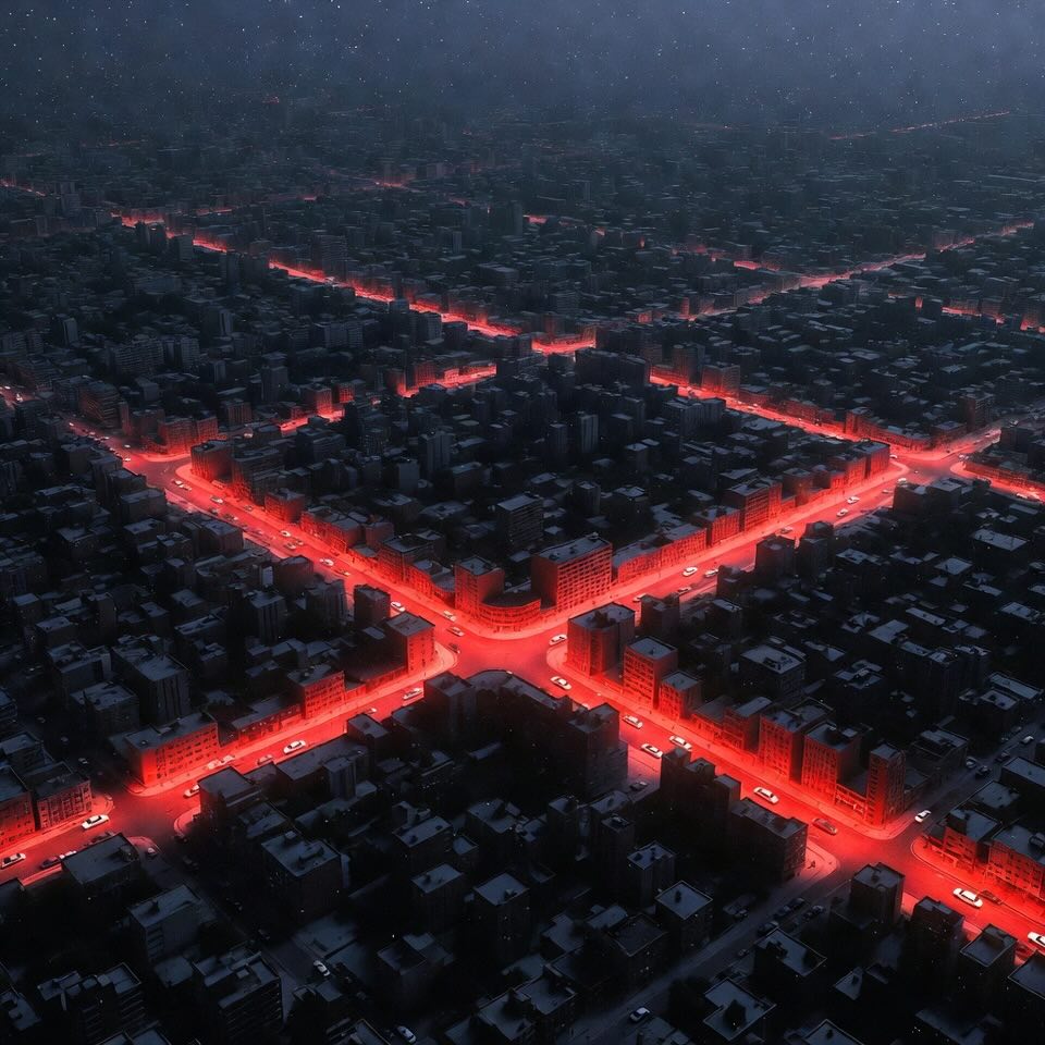
The number of possible subnetworks you could choose from a city's road graph is astronomically large. Manhattan alone has roughly 7,000 directed road segments after preprocessing. Trying every possible combination is completely infeasible — the search space is larger than the number of atoms in the observable universe.
The MIT researchers formalized this challenge as the Autonomous Mobility-on-Demand Network Design Problem, or AMoD-NDP for short. The goal: maximize operator profit by jointly selecting which road segments to instrument and how to route all passengers, while respecting a budget for infrastructure investment, a budget for fleet time (which directly proxies fleet size), and quality-of-service guarantees for every single passenger.
The core technical breakthrough is an efficient algorithm based on a technique called Column Generation — a classic tool in mathematical optimization, here cleverly adapted to the unique structure of robotaxi network design.
Here's the intuition. The problem has a potentially enormous number of possible passenger routes (one for every possible path through every possible subnetwork). Instead of considering all of them at once — which is impossible — the algorithm starts with a small, manageable set of routes and solves the optimization over just those. It then asks: is there any route we're ignoring that would improve the solution? Finding such a route reduces to a well-studied algorithmic problem called the Shortest Path with Resource Constraints, which the team solves exactly using a tailored label-correcting search.
The algorithm adds promising new routes one by one, re-optimizes, and repeats — until no improving route can be found. At that point, it has the provably optimal solution to the continuous (LP) relaxation of the problem, along with a guaranteed bound on how far the final integer solution deviates from the true optimum.
"It turns out you don't need to wire up the whole city. A well-chosen handful of corridors, designed in tandem with the right fleet size, gets you surprisingly close to the best possible outcome."
Crucially, when tested on real Manhattan data — 31 days of taxi trips from May 2024, mapped onto a network of ~4,300 nodes and 7,000 road segments — the algorithm solved each instance to near-optimality within 25 minutes on a standard computing cluster. That's genuinely fast for a problem of this scale and complexity.
Running the framework on real NYC data produced several striking findings.
First, the optimal subnetwork is sparser than you might expect. Not every local street needs to be instrumented. The algorithm naturally identifies the key corridors — the arterials and connectors that carry the bulk of passenger demand — and focuses investment there. Equipping the whole city would be a waste; a well-chosen subset does nearly as well at a fraction of the cost.
Second, and perhaps most reassuringly, the optimal subnetwork is remarkably stable across days. Across all 31 daily demand instances, more than 90% of the edges that appeared in any optimal solution appeared in over 25 of the 31 solutions. This means the designed network is not an artifact of one unusual day of demand — it captures the genuine structural patterns of urban mobility. An operator can plan their infrastructure once and rely on it remaining near-optimal for a long time.
One of the most practically useful outputs of the study is the profit surface — a map of how profitability changes as you vary both the infrastructure budget and the fleet-time budget simultaneously. Three distinct operational regimes emerge:
Fleet-Limited
When you have too few vehicles, adding more road infrastructure barely helps. Cars are the binding constraint — spend money there first.
Budget-Limited
When road infrastructure is scarce, adding more cars also fails to help — there simply aren't enough instrumented streets to send them on. Infrastructure is the bottleneck.
Capacity-Limited
When both resources are plentiful, the physical capacity of the road network itself caps your profit. No amount of extra spending helps beyond this ceiling.
This insight has real policy teeth. If a city imposes a cap on the number of autonomous vehicles allowed on the road — a regulatory tool already discussed in several jurisdictions — the framework can quantify exactly how much profit that cap costs the operator and how much congestion it saves the city. It turns a political debate into a quantifiable engineering trade-off.
One of the most elegant extensions of the framework addresses operational risk. Unprotected left turns are a notorious challenge for autonomous vehicles — they require navigating oncoming traffic, pedestrians, and complex signal timings simultaneously. Waymo and others have identified left-turn handling as a key benchmark for AV safety.
The MIT model allows operators to add a simple constraint: the total number of left turns performed by the fleet across the entire day cannot exceed a given budget. This transforms left-turn avoidance from an informal engineering preference into a hard, mathematically enforceable system-level guarantee.
The case study shows that tightening this constraint sharply — forcing very few left turns — significantly reduces both served demand and profit, because many routes become inadmissible. But as the left-turn budget grows, performance rapidly recovers and eventually plateaus. The framework lets an operator find the sweet spot: the minimum left-turn budget beyond which additional flexibility yields negligible benefit.
The researchers also extended their framework to handle real-world uncertainty. When travel times or passenger demand fluctuate day to day, the "robust" version of the algorithm inflates its estimates conservatively, designing a network that remains safe and profitable across a range of scenarios — not just the average case.
This research matters because robotaxi deployments are entering a critical strategic phase. The easy part — demonstrating that AVs can navigate city streets — has largely been done. The hard part — building services that are economically viable, operationally reliable, and politically acceptable — is what's next.
The AMoD-NDP framework directly addresses that challenge. It gives operators a principled way to answer: where should we launch? How large a network do we really need? What's the minimum fleet we can get away with? What safety constraints can we satisfy without sacrificing too much revenue?
For cities and municipalities, it offers something equally valuable: a tool to rigorously evaluate the trade-offs of regulatory decisions before implementing them. Capping fleet sizes, restricting access to certain neighborhoods, mandating certain routing behaviors — all of these can now be analyzed quantitatively, not just debated politically.
The authors are candid about the limitations of the current model. It is a static framework — it designs the network for an average day, without explicitly modeling how vehicles rebalance themselves over the course of the day when supply and demand shift hour by hour. Incorporating those dynamics would require a much more complex "time-expanded" network model.
Future research directions include richer uncertainty models beyond the simple box uncertainty used here, tighter integration with public transit networks (so that robotaxis complement rather than compete with buses and trains), and fully dynamic design-and-control frameworks that jointly optimize the network design and the real-time fleet management policy simultaneously.
But even in its current form, the work represents a meaningful step forward. It is one of the first rigorous, scalable treatments of the where question in autonomous mobility — and in a field where most research has focused on the how, that is a contribution worth paying attention to.
The age of robotaxis is coming. Thanks to work like this, the streets they drive on may be chosen a lot more intelligently than you'd expect.
Autonomous Mobility-on-Demand (AMoD)
A ride-hailing service where self-driving vehicles are centrally owned and dispatched by a single operator, with no human drivers involved.
Operational Design Domain (ODD)
The specific conditions and environments — roads, weather, speeds — within which an autonomous vehicle is certified to operate safely.
Mixed-Integer Linear Program (MILP)
A mathematical optimization problem where some decisions must be whole numbers (like "yes/no" infrastructure choices) while others can be continuous (like passenger flow volumes). - More about this concept in the article "Smarter HVAC Systems with AI".
Column Generation
An algorithmic technique that solves massive optimization problems by working with a small manageable subset of options first, then smartly adding new ones only when they can improve the solution.
Quality of Service (QoS)
A guaranteed minimum standard of experience for every user — in this context, things like a maximum acceptable travel time or a limit on risky driving maneuvers per route.
Xinling Li, Gioele Zardini. Where Should Robotaxis Operate? Strategic Network Design for Autonomous Mobility-on-Demand. https://doi.org/10.48550/arXiv.2602.19341