A new study combines satellite radar imagery with terrain-based flooding analysis (TCI) to identify recurring urban flood hotspots in Beaumont, Texas, creating a cost-effective framework to improve early flood warning and prioritize drainage upgrades.
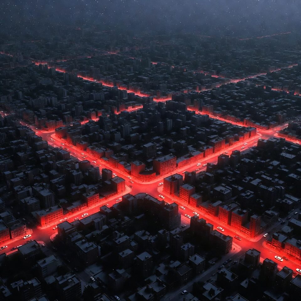
Urban flooding is becoming a daily headache for many cities—roads turning into rivers, cars splashing through unexpected puddles, and neighborhoods getting trapped by shallow but stubborn floodwaters. These aren’t dramatic hurricanes or once-in-a-century disasters… they’re nuisance floods 🌊—small, frequent, and incredibly disruptive.
A new study from Lamar University and the University of Texas at El Paso takes a fresh, clever approach to tackling this problem. Instead of relying only on huge hydrological models that need tons of data, the researchers combined topographic analysis (how land shape affects water flow) with Sentinel-1 satellite radar imagery to identify where floodwater tends to stick around in cities.
Their testbed? Beaumont, Texas, one of the most flood-prone urban areas along the U.S. Gulf Coast.
In this EngiSphere breakdown, we'll simplify the research, add context, sprinkle emojis, and show why this method could be a big win for next-generation early flood warning systems.
When people hear “flooding,” they imagine hurricanes or overflowing rivers. But nuisance flooding is much more common—and often overlooked. These events usually involve 3–10 cm of standing water, just enough to:
In the U.S. alone, nuisance floods caused over $567 million in losses in 2020, even without major storms.
Beaumont, Texas, is especially vulnerable because of:
The problem? These small floods are hard to map and predict because they drain quickly and often vanish before sensors or satellites capture them.
This study aims to fix that.
The researchers combined two powerful tools:
TCI is a terrain-based indicator that quantifies how likely an area is to accumulate water. It uses:
Higher TCI = higher flood likelihood
Radar images can detect water even through:
Because flooded areas reflect radar waves differently, SAR imagery highlights where water is present—even in urban environments.
Instead of trying to model entire stormwater systems, the team fused TCI + radar-detected "water pixels" to identify locations that repeatedly flood, and how often.
This frequency-based method is PERFECT for:
The workflow (shown in the paper’s Figure 1) included several stages:
Using high-resolution 1-meter LiDAR data, the team identified 378 natural and man-made depressions that could hold water.
Filters ensured only meaningful depressions were analyzed:
Each depression’s watershed, slope, and ponding volume were calculated to compute TCI.
TCI values were grouped into:
And it works surprisingly well:
Sentinel-1 doesn’t capture images every day, and floodwater drains quickly in urban systems.
Out of 159 significant rain events (2014–2024), only six had radar images taken within 6 hours of peak rainfall.
These 6 events became the backbone of the flood frequency map.
Why 6 hours?
Because after 6 hours, stormwater often dissipates, making floods invisible from satellites.
Using SNAP and GIS tools:
Then “wet-day minus dry-day” comparisons highlighted only pixels that represented actual water.
This produced water maps for each of the 6 flood events.
Validation used a network of 49 flood sensors around Beaumont.
Results:
A perfect precision score means radar NEVER falsely claimed water where none existed.
The lower recall comes from water draining before the satellite passed.
Pixels appearing as water:
The flood frequency map revealed:
Of the 378 depressions identified:
❗ 99 natural depressions remained flood-vulnerable
And the most important part:
74 of these have medium-to-high TCI values → These are the most dangerous nuisance flood hotspots.
These represent areas where:
Two main reasons:
Images were taken ~6 hours after rainfall peaks.
Some depressions drained before detection.
Not all areas had functioning sensors on all wet days.
Even without perfect timing, the method still showed strong alignment between high-TCI areas and known flood zones.
This combined TCI + radar approach gives cities a powerful, low-cost tool for:
Because both LiDAR-based TCI and radar imagery are publicly available, the method is scalable and inexpensive, making it suitable for:
The study acknowledges that flood drainage happens quickly, and radar timing limits detection. But the groundwork opens doors for smarter systems:
1. Integrating Stormwater Network Data - Add information about:
2. Using Next-Gen Satellites - Higher revisit frequency (e.g., 1–3 hours) would capture more floods.
3. Machine Learning Flood Prediction - Combine radar, TCI, rainfall, and historical flood data
→ predictive early flood warning models
4. Green Infrastructure Planning - Flood-prone depressions now identified could benefit from:
5. Smart Flood Sensor Deployment - Place sensors in the 74 high-priority depressions for real-time alerts.
This research offers a refreshing, practical method for identifying recurring nuisance flood hotspots without needing large-scale flood models. By merging the shape of the land (TCI) with actual satellite-observed water, the team created a reliable, repeatable system that cities can use to protect communities—and build smarter early flood warning systems.
As flooding becomes more frequent with climate change and urbanization, tools like this will be essential for making our cities safer, smarter, and more resilient.
Pluvial Flooding - Flooding caused directly by heavy rainfall overwhelming drainage systems, not by rivers or the sea.
Urban Depression - A naturally low-lying spot in a city where rainwater tends to collect and pool after storms.
Sentinel-1 SAR (Synthetic Aperture Radar) - A European radar satellite that can “see” the ground through clouds and darkness to detect water. - More about this concept in the article "UAV Radar Imaging Reimagined for Smarter Skies".
Water Pixels - Radar image pixels that appear darker because they reflect water, helping satellites identify flooded areas.
LiDAR DEM (Digital Elevation Model) - A high-resolution 3D map of the ground created using laser scanning to show slopes, depressions, and land height. - More about this concept in the article "LiDAR + Fast Fourier Transform: Revolutionizing Digital Terrain Mapping".
Topographic Control Index (TCI) - A terrain-based score that predicts how likely an area is to hold water based on slope, catchment size, and storage capacity.
PRISM Rainfall Data - High-quality climate data used to estimate daily rainfall across large areas.
Early Flood Warning System - A monitoring and alert system that warns communities before or during flooding using sensors, satellites, and models. - More about this concept in the article "Flood Ready: How Mobile Apps Are Revolutionizing Disaster Preparedness (And What’s Next!)".
Flood Frequency Map - A map showing how often specific areas flood by counting repeated flood detections across multiple events.
Detention Pond - A man-made basin designed to temporarily store stormwater and slowly release it to prevent flooding.
Stage Sensor - A ground-based device that measures water level rise in real time to monitor flooding.
Precision & Recall (Validation Metrics) - Statistics used to judge how accurately radar images detect real floodwater compared to ground sensors.
Bakhrel, U.; Brake, N.; Feizbahr, M.; Kim, Y.J.; Hariri Asli, H.; Haselbach, L.; Macon, S.J. Identifying Urban Pluvial Frequency Flooding Hotspots Using the Topographic Control Index and Remote Sensing Radar Images for Early Warning Systems. Water 2025, 17, 3500. https://doi.org/10.3390/w17243500